VAC chart of UIAA
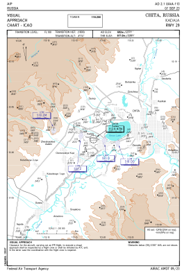 IAC chart of UIAA
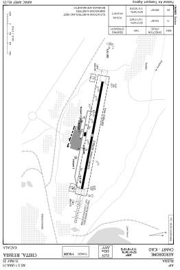
 ADC chart of UIAA
 Satellite view of UIAA
IAC chart of UIAAADC chart of UIAA
Satellite view of UIAA
Sorry, we have no imagery here.
Sorry, we have no imagery here.
Sorry, we have no imagery here.
Sorry, we have no imagery here.
Sorry, we have no imagery here.
Sorry, we have no imagery here.


UIAA - Chita/Kadala
Located in Chita, Russian Federation
ICAO - UIAA, IATA - HTA
Data provided by AirmateGeneral information
Coordinates: N52°1'34" E113°18'18"
Elevation is 2270 feet MSL.
View others Airports in Zabaykalsky Krai
Operational data
Special qualification required
Current time UTC:
Current local time:
Weather
METAR: UIAA 280530Z 05002MPS 4500 FU SCT033 30/06 Q0995 R29/CLRD58 NOSIG RMK QFE688/0918
Communications frequencies: [VIEW]
Runways:
| RWY identifier | QFU | Length (ft) | Width (ft) | Surface | LDA (ft) |
| 11 | 101° | 9183 | 184 | CON | |
| 29 | 281° | 9183 | 184 | CON |
Airport contact information
Address: Chita Russian Federation
Satellite view of UIAA
Sorry, we have no imagery here.
Sorry, we have no imagery here.
Sorry, we have no imagery here.
Sorry, we have no imagery here.
Sorry, we have no imagery here.
Sorry, we have no imagery here.