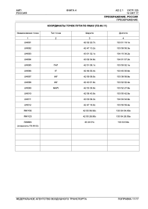
IAC chart of UHTR
 Satellite view of UHTR
Satellite view of UHTR
Sorry, we have no imagery here.
Sorry, we have no imagery here.
Sorry, we have no imagery here.
Sorry, we have no imagery here.
Sorry, we have no imagery here.
Sorry, we have no imagery here.


UHTR - PREOBRAZHENIYE
Located in Preobrazheniye, Russian Federation
ICAO - , IATA -
Data provided by AirmateGeneral information
Coordinates: N42°55'18" E133°54'16"
Elevation is 33 feet MSL.
Magnetic variation is -10° East View others Airports in Primorsky Krai
Operational data
Special qualification required
Current time UTC:
Current local time:
Weather at : - ( 0 km )
METAR: YSNF 240212Z AUTO 08017G28KT 9999 // SCT026 BKN032 BKN043 21/16 Q1023
Communications frequencies: [VIEW]
Runways:
| RWY identifier | QFU | Length (ft) | Width (ft) | Surface | LDA (ft) |
| 05 | 37° | 2756 | 131 | DIRT | |
| 23 | 217° | 2756 | 131 | DIRT |
Airport contact information
Address: Preobrazheniye Russian Federation
Satellite view of UHTR
Sorry, we have no imagery here.
Sorry, we have no imagery here.
Sorry, we have no imagery here.
Sorry, we have no imagery here.
Sorry, we have no imagery here.
Sorry, we have no imagery here.