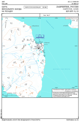
VAC chart of UHML
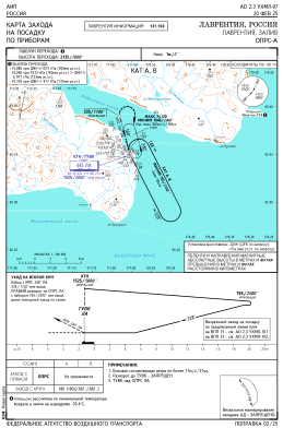
 IAC chart of UHML
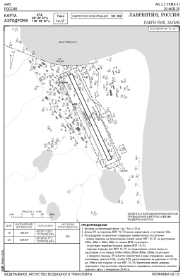
 ADC chart of UHML
 Satellite view of UHML
IAC chart of UHMLADC chart of UHML
Satellite view of UHML
Sorry, we have no imagery here.
Sorry, we have no imagery here.
Sorry, we have no imagery here.
Sorry, we have no imagery here.
Sorry, we have no imagery here.
Sorry, we have no imagery here.


UHML - Lavrentiya
Located in Lavrentiya, Russian Federation
ICAO - UHML, IATA -
Data provided by AirmateGeneral information
Coordinates: N65°34'48" W170°59'48"
Elevation is 13 feet MSL.
Magnetic variation is 5° East View others Airports in Chukotka Autonomous Okrug
Operational data
Special qualification required
Current time UTC:
Current local time:
Communications frequencies: [VIEW]
Runways:
| RWY identifier | QFU | Length (ft) | Width (ft) | Surface | LDA (ft) |
| 15 | 155° | 4619 | 197 | DIRT | 4619 |
| 33 | 335° | 4619 | 197 | DIRT | 4619 |
Airport contact information
Address: Lavrentiya Russian Federation
Satellite view of UHML
Sorry, we have no imagery here.
Sorry, we have no imagery here.
Sorry, we have no imagery here.
Sorry, we have no imagery here.
Sorry, we have no imagery here.
Sorry, we have no imagery here.