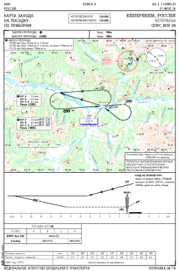
IAC chart of UHMK
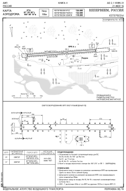
 ADC chart of UHMK
 Satellite view of UHMK

ADC chart of UHMK
Satellite view of UHMK
Sorry, we have no imagery here.
Sorry, we have no imagery here.
Sorry, we have no imagery here.
Sorry, we have no imagery here.
Sorry, we have no imagery here.
Sorry, we have no imagery here.


UHMK - Keperveem Airport
Located in Keperveem, Russian Federation
ICAO - UHMK, IATA -
Data provided by AirmateGeneral information
Coordinates: N67°50'50" E166°8'19"
Elevation is 623 feet MSL.
View others Airports in Chukotka Autonomous Okrug
Operational data
Special qualification required
Current time UTC:
Current local time:
Weather at : - ( 0 km )
METAR: KY19 280435Z AUTO 02005KT 10SM BKN055 OVC070 11/11 A3019 RMK AO2
Communications frequencies: [VIEW]
Runways:
| RWY identifier | QFU | Length (ft) | Width (ft) | Surface | LDA (ft) |
| 09 | 0° | 8126 | 203 | UNK | |
| 27 | 0° | 8126 | 203 | UNK |
Airport contact information
Address: Keperveem Russian Federation
Satellite view of UHMK
Sorry, we have no imagery here.
Sorry, we have no imagery here.
Sorry, we have no imagery here.
Sorry, we have no imagery here.
Sorry, we have no imagery here.
Sorry, we have no imagery here.