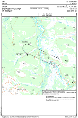
VAC chart of UHEI
 Satellite view of UHEI
Satellite view of UHEI
Sorry, we have no imagery here.
Sorry, we have no imagery here.
Sorry, we have no imagery here.
Sorry, we have no imagery here.
Sorry, we have no imagery here.
Sorry, we have no imagery here.


UHEI - Ilirney
Located in Ilirnei, Russian Federation
ICAO - , IATA -
Data provided by AirmateGeneral information
Coordinates: N67°15'19" E167°56'57"
Elevation is 1165 feet MSL.
Magnetic variation is -6° East View others Airports in Chukotka Autonomous Okrug
Operational data
Special qualification required
Current time UTC:
Current local time:
Weather at : - ( 0 km )
METAR: PKMJ 290757Z 05015KT 15SM SCT014 BKN050 OVC300 28/24 A2987 RMK LAST
Communications frequencies: [VIEW]
Runways:
| RWY identifier | QFU | Length (ft) | Width (ft) | Surface | LDA (ft) |
| 12 | 115° | 2297 | 98 | DIRT | 2297 |
| 30 | 295° | 2297 | 98 | DIRT | 2297 |
Airport contact information
Address: Ilirnei Russian Federation
Satellite view of UHEI
Sorry, we have no imagery here.
Sorry, we have no imagery here.
Sorry, we have no imagery here.
Sorry, we have no imagery here.
Sorry, we have no imagery here.
Sorry, we have no imagery here.