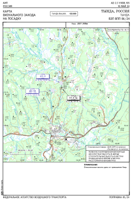
VAC chart of UHBW
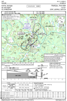
 IAC chart of UHBW
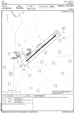
 ADC chart of UHBW
 Satellite view of UHBW
IAC chart of UHBWADC chart of UHBW
Satellite view of UHBW
Sorry, we have no imagery here.
Sorry, we have no imagery here.
Sorry, we have no imagery here.
Sorry, we have no imagery here.
Sorry, we have no imagery here.
Sorry, we have no imagery here.


UHBW - Tynda Airport
Located in Tynda, Russian Federation
ICAO - UHBW, IATA - TYD
Data provided by AirmateGeneral information
Coordinates: N55°17'3" E124°46'44"
Elevation is 2021 feet MSL.
View others Airports in Amur Oblast
Operational data
Special qualification required
Current time UTC:
Current local time:
Weather at : - ( 0 km )
METAR: KFDK 280405Z AUTO 03006KT OVC070 12/11 A3030 RMK AO2
Communications frequencies: [VIEW]
Runways:
| RWY identifier | QFU | Length (ft) | Width (ft) | Surface | LDA (ft) |
| 06 | 0° | 6309 | 115 | UNK | |
| 24 | 0° | 6309 | 115 | UNK |
Airport contact information
Address: Tynda Russian Federation
Satellite view of UHBW
Sorry, we have no imagery here.
Sorry, we have no imagery here.
Sorry, we have no imagery here.
Sorry, we have no imagery here.
Sorry, we have no imagery here.
Sorry, we have no imagery here.