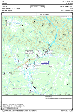
VAC chart of UHBE
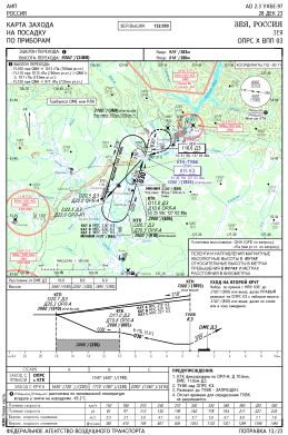
 IAC chart of UHBE
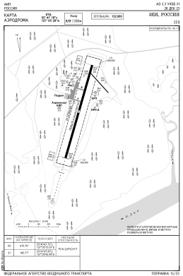
 ADC chart of UHBE
 Satellite view of UHBE
IAC chart of UHBEADC chart of UHBE
Satellite view of UHBE
Sorry, we have no imagery here.
Sorry, we have no imagery here.
Sorry, we have no imagery here.
Sorry, we have no imagery here.
Sorry, we have no imagery here.
Sorry, we have no imagery here.


UHBE - Zeya Airport
Located in Zeya, Russian Federation
ICAO - UHBE, IATA -
Data provided by AirmateGeneral information
Coordinates: N53°41'18" E127°5'27"
Elevation is 928 feet MSL.
View others Airports in Amur Oblast
Operational data
Special qualification required
Current time UTC:
Current local time:
Weather at : - ( 0 km )
METAR: UNEE 252246Z 33003MPS 5000 -SHRA BR BKN002 OVC016CB 09/09 Q1007 R23/290155 NOSIG RMK QFE732
Communications frequencies: [VIEW]
Runways:
| RWY identifier | QFU | Length (ft) | Width (ft) | Surface | LDA (ft) |
| 03 | 0° | 6332 | 115 | UNK | |
| 21 | 0° | 6332 | 115 | UNK |
Airport contact information
Address: Zeya Russian Federation
Satellite view of UHBE
Sorry, we have no imagery here.
Sorry, we have no imagery here.
Sorry, we have no imagery here.
Sorry, we have no imagery here.
Sorry, we have no imagery here.
Sorry, we have no imagery here.