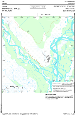
VAC chart of UHAL
 Satellite view of UHAL
Satellite view of UHAL
Sorry, we have no imagery here.
Sorry, we have no imagery here.
Sorry, we have no imagery here.
Sorry, we have no imagery here.
Sorry, we have no imagery here.
Sorry, we have no imagery here.


UHAL - Lamutskoye
Located in Lamutskoe, Russian Federation
ICAO - , IATA -
Data provided by AirmateGeneral information
Coordinates: N65°32'20" E168°50'39"
Elevation is 613 feet MSL.
Magnetic variation is -5° East View others Airports in Chukotka Autonomous Okrug
Operational data
Special qualification required
Current time UTC:
Current local time:
Weather at : - ( 0 km )
METAR: UMKK 221532Z 05005MPS 030V090 9999 FEW040 12/05 Q1006 R24/19//95 NOSIG RMK QFE753/1005
Communications frequencies: [VIEW]
Runways:
| RWY identifier | QFU | Length (ft) | Width (ft) | Surface | LDA (ft) |
| 13 | 126° | 2297 | 197 | DIRT | 2297 |
| 31 | 306° | 2297 | 197 | DIRT | 2297 |
Airport contact information
Address: Lamutskoe Russian Federation
Satellite view of UHAL
Sorry, we have no imagery here.
Sorry, we have no imagery here.
Sorry, we have no imagery here.
Sorry, we have no imagery here.
Sorry, we have no imagery here.
Sorry, we have no imagery here.