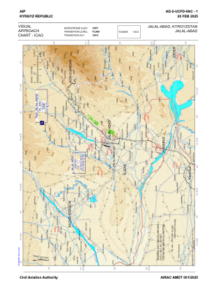
VAC chart of UCFD
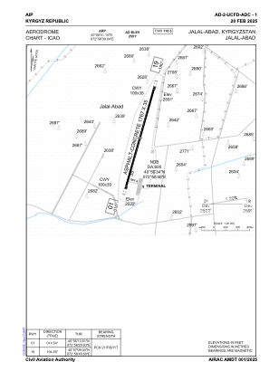
 ADC chart of UCFD
 Satellite view of UCFD
ADC chart of UCFD
Satellite view of UCFD
Sorry, we have no imagery here.
Sorry, we have no imagery here.
Sorry, we have no imagery here.
Sorry, we have no imagery here.
Sorry, we have no imagery here.
Sorry, we have no imagery here.


UCFD - Jalal-Abad
Located in Jalal-Abad, Kyrgyzstan
ICAO - , IATA -
Data provided by AirmateGeneral information
Coordinates: N40°56'41" E72°58'39"
Elevation is 2591 feet MSL.
Magnetic variation is +5° East View others Airports in Jalal-Abad
Operational data
Special qualification required
Current time UTC:
Current local time:
Weather at : UCFO - Osh ( 40 km )
METAR: UCFO 231530Z 24003MPS 9000 SCT043CB 25/09 Q1015 NOSIG
TAF: TAF UCFO 231044Z 2312/2412 18005MPS 6000 SCT030CB BKN100 TEMPO 2312/2318 VRB10G15MPS 2000 TSRA DU SCT007 BKN020CB TEMPO 2318/2324 VRB09MPS 2000 TSRA SCT007 BKN020CB BECMG 2402/2404 30003MPS
Communications frequencies: [VIEW]
Runways:
| RWY identifier | QFU | Length (ft) | Width (ft) | Surface | LDA (ft) |
| 01 | 15° | 5797 | 115 | CONC+ASPH | 5797 |
| 19 | 195° | 5797 | 115 | CONC+ASPH | 5797 |
Airport contact information
Address: Jalal-Abad Kyrgyzstan
Satellite view of UCFD
Sorry, we have no imagery here.
Sorry, we have no imagery here.
Sorry, we have no imagery here.
Sorry, we have no imagery here.
Sorry, we have no imagery here.
Sorry, we have no imagery here.