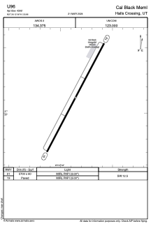
ADC chart of U96
 Satellite view of U96
Satellite view of U96
Sorry, we have no imagery here.
Sorry, we have no imagery here.
Sorry, we have no imagery here.
Sorry, we have no imagery here.
Sorry, we have no imagery here.
Sorry, we have no imagery here.


U96 - Cal Black Meml
Located in Halls Crossing, United States
ICAO - U96, IATA -
Data provided by AirmateGeneral information
Coordinates: N37°26'7" W110°33'51"
Elevation is 4395 feet MSL.
Magnetic variation is 13° East View others Airports in Utah
Operational data
Special qualification required
Current time UTC:
Current local time:
Weather at : - ( 0 km )
METAR: ZMUB 011600Z VRB01MPS CAVOK M08/M12 Q1018 NOSIG RMK QFE656.0 69
Communications frequencies: [VIEW]
Runways:
| RWY identifier | QFU | Length (ft) | Width (ft) | Surface | LDA (ft) |
| 01 | 28° | 5700 | 60 | ASPH | |
| 19 | 208° | 5700 | 60 | ASPH |
Airport contact information
Address: Halls Crossing United States
Satellite view of U96
Sorry, we have no imagery here.
Sorry, we have no imagery here.
Sorry, we have no imagery here.
Sorry, we have no imagery here.
Sorry, we have no imagery here.
Sorry, we have no imagery here.