IAC chart of U64
 ADC chart of U64
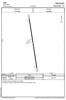
 Satellite view of U64
ADC chart of U64
Satellite view of U64
Sorry, we have no imagery here.
Sorry, we have no imagery here.
Sorry, we have no imagery here.
Sorry, we have no imagery here.
Sorry, we have no imagery here.
Sorry, we have no imagery here.


U64 - Monticello
Located in Monticello, United States
ICAO - U64, IATA -
Data provided by AirmateGeneral information
Coordinates: N37°55'57" W109°20'28"
Elevation is 6970 feet MSL.
Magnetic variation is 09° East View others Airports in Utah
Operational data
Special qualification required
Current time UTC:
Current local time:
Weather at : KBDG - Blanding Muni ( 41 km )
METAR: KBDG 011515Z AUTO 23016G23KT 9SM FEW037 SCT047 BKN055 BKN100 06/M03 A2960 RMK AO2 T00611026 $
Communications frequencies: [VIEW]
Runways:
| RWY identifier | QFU | Length (ft) | Width (ft) | Surface | LDA (ft) |
| 16 | 171° | 5998 | 75 | ASPH | |
| 34 | 351° | 5998 | 75 | ASPH |
Airport contact information
Address: Monticello United States
Satellite view of U64
Sorry, we have no imagery here.
Sorry, we have no imagery here.
Sorry, we have no imagery here.
Sorry, we have no imagery here.
Sorry, we have no imagery here.
Sorry, we have no imagery here.