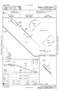
IAC chart of TX2
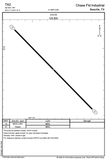
 ADC chart of TX2
 Satellite view of TX2
ADC chart of TX2
Satellite view of TX2
Sorry, we have no imagery here.
Sorry, we have no imagery here.
Sorry, we have no imagery here.
Sorry, we have no imagery here.
Sorry, we have no imagery here.
Sorry, we have no imagery here.


TX2 - Chase Fld Industrial
Located in Beeville, United States
ICAO - TX2, IATA -
Data provided by AirmateGeneral information
Coordinates: N28°21'45" W97°39'43"
Elevation is 184 feet MSL.
Magnetic variation is 04° East View others Airports in Texas
Operational data
Special qualification required
Current time UTC:
Current local time:
Weather at : KBEA - Beeville Muni ( 13 km )
METAR: KBEA 012215Z AUTO 15014G24KT 10SM SCT027 28/21 A2960 RMK AO2 T02840206 PWINO
Communications frequencies: [VIEW]
Runways:
| RWY identifier | QFU | Length (ft) | Width (ft) | Surface | LDA (ft) |
| 13 | 135° | 8000 | 200 | ASPH | |
| 31 | 315° | 8000 | 200 | ASPH |
Airport contact information
Address: Beeville United States
Satellite view of TX2
Sorry, we have no imagery here.
Sorry, we have no imagery here.
Sorry, we have no imagery here.
Sorry, we have no imagery here.
Sorry, we have no imagery here.
Sorry, we have no imagery here.