ADC chart of TA56
 Satellite view of TA56
Satellite view of TA56
Sorry, we have no imagery here.
Sorry, we have no imagery here.
Sorry, we have no imagery here.
Sorry, we have no imagery here.
Sorry, we have no imagery here.
Sorry, we have no imagery here.


TA56 - Floyd Ranch
Located in Orange Grove, United States
ICAO - TA56, IATA -
Data provided by AirmateGeneral information
Coordinates: N28°3'24" W98°8'31"
Elevation is 282 feet MSL.
View others Airports in Texas
Operational data
Special qualification required
Current time UTC:
Current local time:
Weather at : KNOG - Orange Grove Nalf ( 20 km )
METAR: KNOG 021056Z AUTO 15015KT 8SM CLR 23/23 A2950 RMK AO2 SLP969 T02330228 PNO $
Communications frequencies: [VIEW]
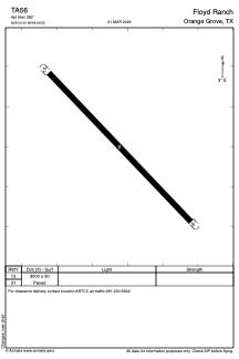
Runways:
| RWY identifier | QFU | Length (ft) | Width (ft) | Surface | LDA (ft) |
| 13 | 0° | 3000 | 30 | ASPH | |
| 31 | 0° | 3000 | 30 | ASPH |
Airport contact information
Address: Orange Grove United States
Satellite view of TA56
Sorry, we have no imagery here.
Sorry, we have no imagery here.
Sorry, we have no imagery here.
Sorry, we have no imagery here.
Sorry, we have no imagery here.
Sorry, we have no imagery here.