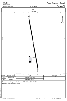
ADC chart of TA25
 Satellite view of TA25
Satellite view of TA25
Sorry, we have no imagery here.
Sorry, we have no imagery here.
Sorry, we have no imagery here.
Sorry, we have no imagery here.
Sorry, we have no imagery here.
Sorry, we have no imagery here.


TA25 - Cook Canyon Ranch
Located in Ranger, United States
ICAO - TA25, IATA -
Data provided by AirmateGeneral information
Coordinates: N32°25'54" W98°35'41"
Elevation is 1476 feet MSL.
Magnetic variation is 05° East View others Airports in Texas
Operational data
Special qualification required
Current time UTC:
Current local time:
Weather at : KETN - Eastland Muni ( 20 km )
METAR: KETN 020015Z AUTO 16020G26KT 10SM SCT110 28/15 A2945 RMK AO2 T02850150
Communications frequencies: [VIEW]
Runways:
| RWY identifier | QFU | Length (ft) | Width (ft) | Surface | LDA (ft) |
| 17 | 0° | 5500 | 75 | CONC | |
| 35 | 0° | 5500 | 75 | CONC |
Airport contact information
Address: Ranger United States
Satellite view of TA25
Sorry, we have no imagery here.
Sorry, we have no imagery here.
Sorry, we have no imagery here.
Sorry, we have no imagery here.
Sorry, we have no imagery here.
Sorry, we have no imagery here.