ADC chart of T93
 Satellite view of T93
Satellite view of T93
Sorry, we have no imagery here.
Sorry, we have no imagery here.
Sorry, we have no imagery here.
Sorry, we have no imagery here.
Sorry, we have no imagery here.
Sorry, we have no imagery here.


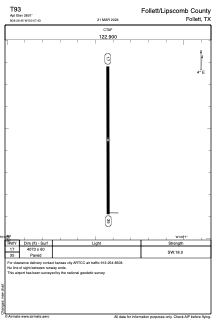
T93 - Follett/Lipscomb County
Located in Follett, United States
ICAO - T93, IATA -
Data provided by AirmateGeneral information
Coordinates: N36°26'27" W100°7'26"
Elevation is 2601 feet MSL.
Magnetic variation is 06° East View others Airports in Texas
Operational data
Special qualification required
Current time UTC:
Current local time:
Weather at : KGAG - Gage ( 35 km )
METAR: KGAG 020953Z AUTO 10SM BKN110 13/04 A2945 RMK AO2 SLP948 T01280044 $
Communications frequencies: [VIEW]
Runways:
| RWY identifier | QFU | Length (ft) | Width (ft) | Surface | LDA (ft) |
| 17 | 180° | 4073 | 60 | ASPH | |
| 35 | 360° | 4073 | 60 | ASPH |
Airport contact information
Address: Follett United States
Satellite view of T93
Sorry, we have no imagery here.
Sorry, we have no imagery here.
Sorry, we have no imagery here.
Sorry, we have no imagery here.
Sorry, we have no imagery here.
Sorry, we have no imagery here.