ADC chart of T60
 Satellite view of T60
Satellite view of T60
Sorry, we have no imagery here.
Sorry, we have no imagery here.
Sorry, we have no imagery here.
Sorry, we have no imagery here.
Sorry, we have no imagery here.
Sorry, we have no imagery here.


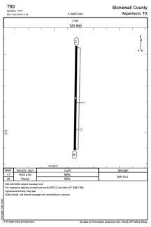
T60 - Stonewall County
Located in Aspermont, United States
ICAO - T60, IATA -
Data provided by AirmateGeneral information
Coordinates: N33°10'13" W100°11'50"
Elevation is 1744 feet MSL.
Magnetic variation is 08° East View others Airports in Texas
Operational data
Special qualification required
Current time UTC:
Current local time:
Weather at : - ( 0 km )
METAR: KSUE 020757Z AUTO 14013KT 1 1/2SM -SN OVC005 A3003 RMK AO2 SLPNO P0000 FZRANO $
Communications frequencies: [VIEW]
Runways:
| RWY identifier | QFU | Length (ft) | Width (ft) | Surface | LDA (ft) |
| 17 | 181° | 4000 | 60 | ASPH | |
| 35 | 1° | 4000 | 60 | ASPH |
Airport contact information
Address: Aspermont United States
Satellite view of T60
Sorry, we have no imagery here.
Sorry, we have no imagery here.
Sorry, we have no imagery here.
Sorry, we have no imagery here.
Sorry, we have no imagery here.
Sorry, we have no imagery here.