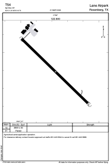
ADC chart of T54
 Satellite view of T54
Satellite view of T54
Sorry, we have no imagery here.
Sorry, we have no imagery here.
Sorry, we have no imagery here.
Sorry, we have no imagery here.
Sorry, we have no imagery here.


T54 - Lane Airpark
Located in Rosenberg, United States
ICAO - T54, IATA -
Data provided by AirmateGeneral information
Coordinates: N29°31'24" W95°46'47"
Elevation is 94 feet MSL.
Magnetic variation is 05° East View others Airports in Texas
Operational data
Special qualification required
Current time UTC:
Current local time:
Weather at : KSGR - Sugar Land Rgnl ( 16 km )
METAR: KSGR 020318Z AUTO 16013KT 10SM OVC014 24/22 A2966 RMK AO2 T02390222
TAF: KSGR 012320Z 0200/0224 17016G26KT P6SM SCT025 BKN035 FM020200 16015G24KT P6SM BKN015 OVC025 FM020800 17019G27KT 6SM BR BKN011 FM021400 17015G26KT P6SM BKN015 OVC025 FM021700 17020G27KT P6SM OVC025
Communications frequencies: [VIEW]
Runways:
| RWY identifier | QFU | Length (ft) | Width (ft) | Surface | LDA (ft) |
| 13 | 0° | 2890 | 35 | ASPH | |
| 31 | 0° | 2890 | 35 | ASPH |
Airport contact information
Address: Rosenberg United States
Satellite view of T54
Sorry, we have no imagery here.
Sorry, we have no imagery here.
Sorry, we have no imagery here.
Sorry, we have no imagery here.
Sorry, we have no imagery here.