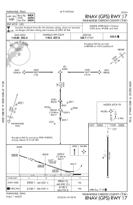
IAC chart of T45
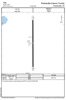
 ADC chart of T45
 Satellite view of T45
ADC chart of T45
Satellite view of T45
Sorry, we have no imagery here.
Sorry, we have no imagery here.
Sorry, we have no imagery here.
Sorry, we have no imagery here.
Sorry, we have no imagery here.
Sorry, we have no imagery here.


T45 - Panhandle-Carson County
Located in Panhandle, United States
ICAO - T45, IATA -
Data provided by AirmateGeneral information
Coordinates: N35°21'42" W101°21'54"
Elevation is 3454 feet MSL.
Magnetic variation is 08° East View others Airports in Texas
Operational data
Special qualification required
Current time UTC:
Current local time:
Weather at : KAMA - Rick Husband Amarillo Intl ( 35 km )
METAR: KAMA 020353Z 24021G28KT 10SM OVC033 23/M03 A2938 RMK AO2 PK WND 22033/0308 SLP897 T02281033 $
TAF: KAMA 012327Z 0200/0224 24025G35KT 6SM BLDU SCT230 FM020500 26022G32KT P6SM BKN140 FM020600 28020G29KT P6SM BKN110 FM021800 27012KT P6SM FEW230
Communications frequencies: [VIEW]
Runways:
| RWY identifier | QFU | Length (ft) | Width (ft) | Surface | LDA (ft) |
| 17 | 180° | 4404 | 60 | ASPH | |
| 35 | 360° | 4404 | 60 | ASPH |
Airport contact information
Address: Panhandle United States
Satellite view of T45
Sorry, we have no imagery here.
Sorry, we have no imagery here.
Sorry, we have no imagery here.
Sorry, we have no imagery here.
Sorry, we have no imagery here.
Sorry, we have no imagery here.