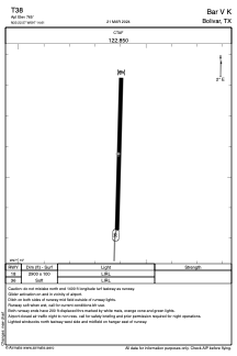
ADC chart of T38
 Satellite view of T38
Satellite view of T38
Sorry, we have no imagery here.
Sorry, we have no imagery here.
Sorry, we have no imagery here.
Sorry, we have no imagery here.
Sorry, we have no imagery here.
Sorry, we have no imagery here.


T38 - Bar V K
Located in Bolivar, United States
ICAO - T38, IATA -
Data provided by AirmateGeneral information
Coordinates: N33°22'35" W97°14'36"
Elevation is 765 feet MSL.
Magnetic variation is 07° East View others Airports in Texas
Operational data
Special qualification required
Current time UTC:
Current local time:
Weather at : KDTO - Denton Enterprise ( 20 km )
METAR: KDTO 020653Z AUTO 17020G32KT 10SM OVC020 23/20 A2947 RMK AO2 PK WND 17033/0604 SLP971 T02280200
Communications frequencies: [VIEW]
Runways:
| RWY identifier | QFU | Length (ft) | Width (ft) | Surface | LDA (ft) |
| 18 | 0° | 2900 | 100 | GRASS | |
| 36 | 0° | 2900 | 100 | GRASS |
Airport contact information
Address: Bolivar United States
Satellite view of T38
Sorry, we have no imagery here.
Sorry, we have no imagery here.
Sorry, we have no imagery here.
Sorry, we have no imagery here.
Sorry, we have no imagery here.
Sorry, we have no imagery here.