ADC chart of T05
 Satellite view of T05
Satellite view of T05
Sorry, we have no imagery here.
Sorry, we have no imagery here.
Sorry, we have no imagery here.
Sorry, we have no imagery here.
Sorry, we have no imagery here.
Sorry, we have no imagery here.


T05 - Charles R Johnson
Located in Port Mansfield, United States
ICAO - T05, IATA -
Data provided by AirmateGeneral information
Coordinates: N26°33'37" W97°26'21"
Elevation is 10 feet MSL.
Magnetic variation is 07° East View others Airports in Texas
Operational data
Special qualification required
Current time UTC:
Current local time:
Weather at : KHRL - Valley Intl ( 43 km )
METAR: KHRL 012152Z 14018G29KT 10SM BKN028 BKN036 29/23 A2959 RMK AO2 PK WND 14030/2133 SLP019 T02940228
TAF: KHRL 011720Z 0118/0218 15021G27KT P6SM BKN035 FM020200 16019G25KT 6SM BR BKN015 FM021300 17021G26KT 4SM BR BKN025 FM021500 18024G30KT 6SM HZ BKN025 FM021700 18020G26KT P6SM SKC
Communications frequencies: [VIEW]
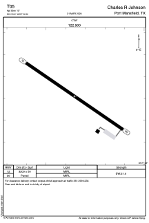
Runways:
| RWY identifier | QFU | Length (ft) | Width (ft) | Surface | LDA (ft) |
| 12 | 124° | 3200 | 50 | ASPH | |
| 30 | 304° | 3200 | 50 | ASPH |
Airport contact information
Address: Port Mansfield United States
Satellite view of T05
Sorry, we have no imagery here.
Sorry, we have no imagery here.
Sorry, we have no imagery here.
Sorry, we have no imagery here.
Sorry, we have no imagery here.
Sorry, we have no imagery here.