IAC chart of SVST
 ADC chart of SVST
 Satellite view of SVST
ADC chart of SVST
Satellite view of SVST
Sorry, we have no imagery here.
Sorry, we have no imagery here.
Sorry, we have no imagery here.
Sorry, we have no imagery here.
Sorry, we have no imagery here.
Sorry, we have no imagery here.


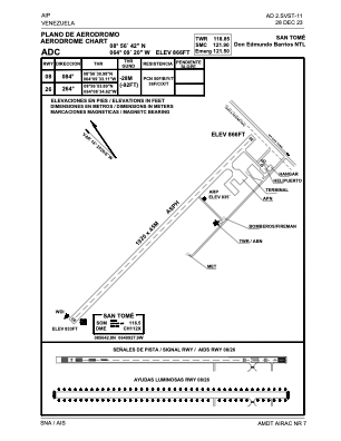
SVST - San Tome / Don Edmundo Barrios Ntl
Located in San Tome, Venezuela
ICAO - SVST, IATA - SOM
Data provided by AirmateGeneral information
Coordinates: N8°56'42" W64°9'3"
Elevation is 866 feet MSL.
Magnetic variation is -14° East View others Airports in Anzoategui
Operational data
Special qualification required
Current time UTC:
Current local time:
Weather at : - ( 0 km )
METAR: ULLI 110451Z 20004MPS 120V260 8000 3400SW -SHSN FEW011 BKN018CB OVC036 M02/M03 Q0994 R28L/590531 NOSIG
Communications frequencies: [VIEW]
Runways:
| RWY identifier | QFU | Length (ft) | Width (ft) | Surface | LDA (ft) |
| 08 | 68° | 6302 | 150 | ASPH | 6299 |
| 26 | 248° | 6302 | 150 | ASPH | 6299 |
Airport contact information
Address: San Tome Venezuela
Satellite view of SVST
Sorry, we have no imagery here.
Sorry, we have no imagery here.
Sorry, we have no imagery here.
Sorry, we have no imagery here.
Sorry, we have no imagery here.
Sorry, we have no imagery here.