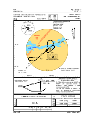
IAC chart of SVCB
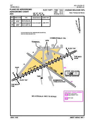
 ADC chart of SVCB
 Satellite view of SVCB
ADC chart of SVCB
Satellite view of SVCB
Sorry, we have no imagery here.
Sorry, we have no imagery here.
Sorry, we have no imagery here.
Sorry, we have no imagery here.
Sorry, we have no imagery here.
Sorry, we have no imagery here.


SVCB - Ciudad Bolivar / Gral. Tomas De Heres
Located in Ciudad Bolivar, Venezuela
ICAO - SVCB, IATA - CBL
Data provided by AirmateGeneral information
Coordinates: N8°7'20" W63°32'14"
Elevation is 164 feet MSL.
Magnetic variation is -14° East View others Airports in Bolívar
Operational data
Special qualification required
Current time UTC:
Current local time:
Communications frequencies: [VIEW]
Runways:
| RWY identifier | QFU | Length (ft) | Width (ft) | Surface | LDA (ft) |
| 07 | 56° | 4885 | 148 | ASPH | 4892 |
| 25 | 236° | 4885 | 148 | ASPH | 4892 |
Airport contact information
Address: Ciudad Bolivar Venezuela
Satellite view of SVCB
Sorry, we have no imagery here.
Sorry, we have no imagery here.
Sorry, we have no imagery here.
Sorry, we have no imagery here.
Sorry, we have no imagery here.
Sorry, we have no imagery here.