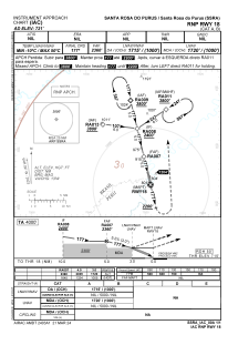
IAC chart of SSRA
 Satellite view of SSRA
Satellite view of SSRA
Sorry, we have no imagery here.
Sorry, we have no imagery here.
Sorry, we have no imagery here.
Sorry, we have no imagery here.
Sorry, we have no imagery here.
Sorry, we have no imagery here.


SSRA - Santa Rosa Do Purus
Located in Santa Rosa Do Purus, Brazil
ICAO - SSRA, IATA -
Data provided by AirmateGeneral information
Coordinates: S9°26'47" W70°28'58"
Elevation is 721 feet MSL.
Magnetic variation is -8.588119125° East View others Airports in Acre
Operational data
Special qualification required
Current time UTC:
Current local time:
Weather at : - ( 0 km )
METAR: PKWA 101440Z AUTO 08010KT 10SM SCT021 SCT032 27/23 A2980 RMK AO2 T02710233
Communications frequencies: [VIEW]
Runways:
| RWY identifier | QFU | Length (ft) | Width (ft) | Surface | LDA (ft) |
| 17 | 0° | 3609 | 75 | GRASS | |
| 35 | 0° | 3609 | 75 | GRASS | |
| 18 | 0° | 3374 | 75 | GRASS | |
| 36 | 0° | 3374 | 75 | GRASS |
Airport contact information
Address: Santa Rosa Do Purus Brazil
Satellite view of SSRA
Sorry, we have no imagery here.
Sorry, we have no imagery here.
Sorry, we have no imagery here.
Sorry, we have no imagery here.
Sorry, we have no imagery here.
Sorry, we have no imagery here.