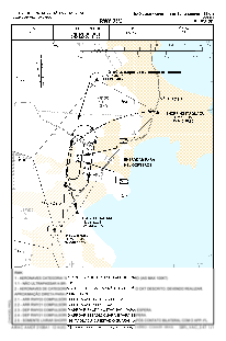
VAC chart of SSKT
 Satellite view of SSKT
Satellite view of SSKT
Sorry, we have no imagery here.
Sorry, we have no imagery here.
Sorry, we have no imagery here.
Sorry, we have no imagery here.
Sorry, we have no imagery here.
Sorry, we have no imagery here.


SSKT - Aeroclube De Santa Catarina
Located in Sao Jose, Brazil
ICAO - SSKT, IATA -
Data provided by AirmateGeneral information
Coordinates: S27°36'43" W48°40'24"
Elevation is 22 feet MSL.
Magnetic variation is -19.710694487° East View others Airports in Santa Catarina
Operational data
Special qualification required
Current time UTC:
Current local time:
Weather at : SBFL - Hercílio Luz ( 14 km )
METAR: SBFL 100900Z 21003KT 9999 VCTS SCT015 FEW030CB BKN070 20/19 Q1013
TAF: TAF SBFL 100900Z 1012/1112 22006KT 8000 -RA BKN018 FEW030TCU TX24/1015Z TN20/1108Z BECMG 1012/1014 15008KT 9999 NSW BKN035 BECMG 1016/1018 8000 -RA BKN027 TEMPO 1020/1102 5000 RA BKN015 FEW030TCU BECMG 1102/1104 22005KT 7000 RA BKN010 BECMG 1107/1109 9999 NSW SCT013 BKN030 BECMG 1109/1111 15007KT SCT025 RMK PEJ
Communications frequencies: [VIEW]
Runways:
| RWY identifier | QFU | Length (ft) | Width (ft) | Surface | LDA (ft) |
| 03 | 0° | 3947 | 59 | ASPH | |
| 21 | 0° | 3947 | 59 | ASPH |
Airport contact information
Address: Sao Jose Brazil
Other aviation service providers
Aviation club (not for profit)

Satellite view of SSKT
Sorry, we have no imagery here.
Sorry, we have no imagery here.
Sorry, we have no imagery here.
Sorry, we have no imagery here.
Sorry, we have no imagery here.
Sorry, we have no imagery here.