VAC chart of SPUR
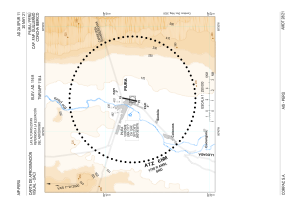 IAC chart of SPUR
 Satellite view of SPUR
IAC chart of SPUR
Satellite view of SPUR
Sorry, we have no imagery here.
Sorry, we have no imagery here.
Sorry, we have no imagery here.
Sorry, we have no imagery here.
Sorry, we have no imagery here.


SPUR - Capitan Fap Guillermo Concha Iberico
Located in Piura, Peru
ICAO - SPUR, IATA - PIU
Data provided by AirmateGeneral information
Coordinates: S5°12'21" W80°36'59"
Elevation is 116 feet MSL.
View others Airports in Piura Region
Operational data
Special qualification required
Current time UTC:
Current local time:
Weather
METAR: SPUR 240300Z 17012KT CAVOK 22/17 Q1013 RMK PP000
TAF: TAF SPUR 232300Z 2400/2424 21012KT CAVOK TX32/2419Z TN19/2411Z BECMG 2405/2407 15006KT TEMPO 2408/2410 BKN015 BECMG 2419/2421 20016KT
Communications frequencies: [VIEW]
Runways:
| RWY identifier | QFU | Length (ft) | Width (ft) | Surface | LDA (ft) |
| 01 | 13° | 8202 | 148 | ASP | |
| 19 | 193° | 8202 | 148 | ASP | |
| 01R | 0° | 7024 | 98 | UNK | |
| 19L | 0° | 7024 | 98 | UNK |
Airport contact information
Address: Piura Peru
Satellite view of SPUR
Sorry, we have no imagery here.
Sorry, we have no imagery here.
Sorry, we have no imagery here.
Sorry, we have no imagery here.
Sorry, we have no imagery here.