VAC chart of SPQU
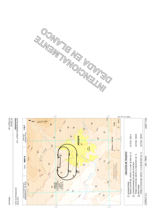 IAC chart of SPQU
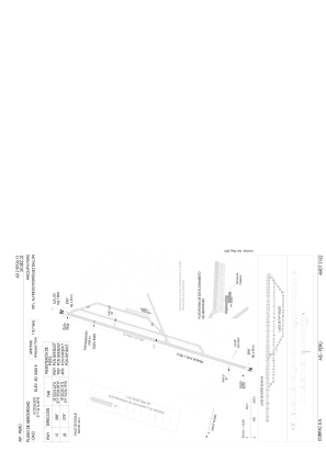
 ADC chart of SPQU
 Satellite view of SPQU

IAC chart of SPQUADC chart of SPQU
Satellite view of SPQU
Sorry, we have no imagery here.
Sorry, we have no imagery here.
Sorry, we have no imagery here.
Sorry, we have no imagery here.
Sorry, we have no imagery here.
Sorry, we have no imagery here.


SPQU - Aeropuerto Internacional Alfredo Rodriguez Ballon
Located in Arequipa, Peru
ICAO - SPQU, IATA - AQP
Data provided by AirmateGeneral information
Coordinates: S16°20'26" W71°34'15"
Elevation is 8405 feet MSL.
View others Airports in Arequipa Region
Operational data
Special qualification required
Current time UTC:
Current local time:
Weather
METAR: SPQU 121900Z 27009KT 240V350 9999 FEW110 20/05 Q1026 NOSIG RMK PP000
TAF: TAF SPQU 121700Z 1218/1318 23012KT 9999 SCT060 BKN090 TX21/1219Z TN11/1311Z FM122130 26007KT 9999 SCT040 BKN060 FM130400 VRB03KT 9999 FEW080 SCT100 FM131200 24006KT 9999 SCT120
Communications frequencies: [VIEW]
Runways:
| RWY identifier | QFU | Length (ft) | Width (ft) | Surface | LDA (ft) |
| 10 | 93° | 9777 | 148 | UNK | |
| 28 | 273° | 9777 | 148 | UNK |
Airport contact information
Address: Arequipa Peru
Satellite view of SPQU
Sorry, we have no imagery here.
Sorry, we have no imagery here.
Sorry, we have no imagery here.
Sorry, we have no imagery here.
Sorry, we have no imagery here.
Sorry, we have no imagery here.