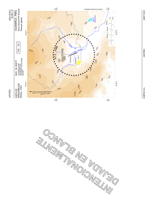
VAC chart of SPJR
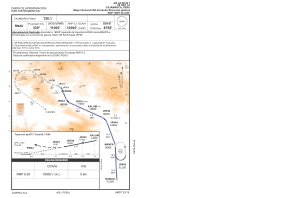
 IAC chart of SPJR
 Satellite view of SPJR
IAC chart of SPJR
Satellite view of SPJR
Sorry, we have no imagery here.
Sorry, we have no imagery here.
Sorry, we have no imagery here.
Sorry, we have no imagery here.
Sorry, we have no imagery here.
Sorry, we have no imagery here.


SPJR - Mayor General Fap Armando Revoredo Iglesias
Located in Cajamarca, Peru
ICAO - SPJR, IATA - CJA
Data provided by AirmateGeneral information
Coordinates: S7°8'21" W78°29'22"
Elevation is 8848 feet MSL.
View others Airports in Cajamarca Region
Operational data
Special qualification required
Current time UTC:
Current local time:
Weather
METAR: SPJR 182200Z VRB04KT 9999 FEW020 19/10 Q1025 RMK TX23.1 PP000
TAF: TAF SPJR 181705Z 1818/1918 18005KT 9999 FEW023 SCT060 TX23/1819Z TN07/1911Z
Communications frequencies: [VIEW]
Runways:
| RWY identifier | QFU | Length (ft) | Width (ft) | Surface | LDA (ft) |
| 16 | 158° | 8202 | 148 | ASP | |
| 34 | 338° | 8202 | 148 | ASP |
Airport contact information
Address: Cajamarca Peru
Satellite view of SPJR
Sorry, we have no imagery here.
Sorry, we have no imagery here.
Sorry, we have no imagery here.
Sorry, we have no imagery here.
Sorry, we have no imagery here.
Sorry, we have no imagery here.