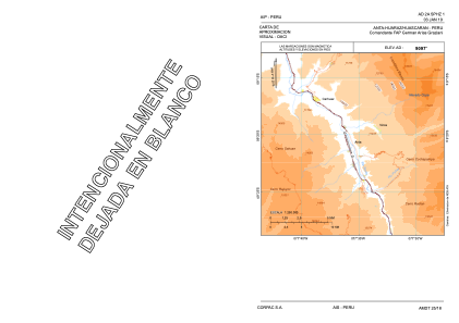
VAC chart of SPHZ
 Satellite view of SPHZ
Satellite view of SPHZ
Sorry, we have no imagery here.
Sorry, we have no imagery here.
Sorry, we have no imagery here.
Sorry, we have no imagery here.
Sorry, we have no imagery here.
Sorry, we have no imagery here.


SPHZ - Comandante Fap German Arias Graziani
Located in Anta-Huaraz, Peru
ICAO - SPHZ, IATA - ATA
Data provided by AirmateGeneral information
Coordinates: S9°21'38" W77°35'38"
Elevation is 9015 feet MSL.
View others Airports in Ancash Region
Operational data
Special qualification required
Current time UTC:
Current local time:
Weather
METAR: SPHZ 101300Z 01003KT 9999 FEW020 SCT080 13/12 Q1030 RMK PP000
Communications frequencies: [VIEW]
Runways:
| RWY identifier | QFU | Length (ft) | Width (ft) | Surface | LDA (ft) |
| 16 | 162° | 9514 | 98 | ASP | |
| 34 | 342° | 9514 | 98 | ASP |
Airport contact information
Address: Anta-Huaraz Peru
Satellite view of SPHZ
Sorry, we have no imagery here.
Sorry, we have no imagery here.
Sorry, we have no imagery here.
Sorry, we have no imagery here.
Sorry, we have no imagery here.
Sorry, we have no imagery here.