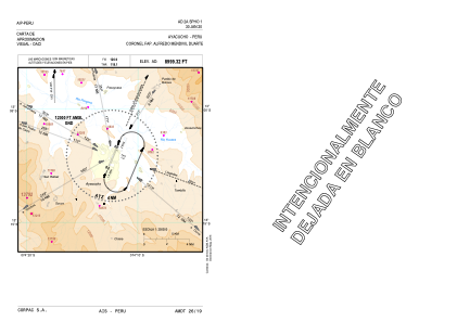
VAC chart of SPHO
 Satellite view of SPHO
Satellite view of SPHO
Sorry, we have no imagery here.
Sorry, we have no imagery here.
Sorry, we have no imagery here.
Sorry, we have no imagery here.
Sorry, we have no imagery here.
Sorry, we have no imagery here.


SPHO - Coronel Fap Alfredo Mendivil Duarte
Located in Ayacucho, Peru
ICAO - SPHO, IATA - AYP
Data provided by AirmateGeneral information
Coordinates: S13°9'17" W74°12'16"
Elevation is 8999 feet MSL.
View others Airports in Ayacucho Region
Operational data
Special qualification required
Current time UTC:
Current local time:
Weather
TAF: TAF AMD SPHO 092140Z 0921/1018 33006KT 9999 FEW040TCU BKN080 TX22/0922Z TN12/1011Z BECMG 0922/0924 SCT080
Communications frequencies: [VIEW]
Runways:
| RWY identifier | QFU | Length (ft) | Width (ft) | Surface | LDA (ft) |
| 02 | 23° | 9186 | 148 | ASP | |
| 20 | 203° | 9186 | 148 | ASP |
Airport contact information
Address: Ayacucho Peru
Satellite view of SPHO
Sorry, we have no imagery here.
Sorry, we have no imagery here.
Sorry, we have no imagery here.
Sorry, we have no imagery here.
Sorry, we have no imagery here.
Sorry, we have no imagery here.