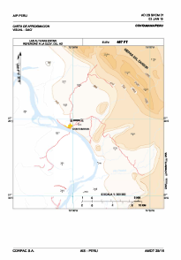
VAC chart of SPCM
 Satellite view of SPCM
Satellite view of SPCM
Sorry, we have no imagery here.
Sorry, we have no imagery here.
Sorry, we have no imagery here.
Sorry, we have no imagery here.
Sorry, we have no imagery here.


SPCM - Contamana
Located in , Peru
ICAO - SPCM, IATA -
Data provided by AirmateGeneral information
Coordinates: S7°20'9" W74°59'33"
Elevation is 480 feet MSL.
View others Airports in Loreto Region
Operational data
Special qualification required
Current time UTC:
Current local time:
Weather at : - ( 0 km )
METAR: PAFE 101108Z AUTO 10006KT 10SM -RA BKN024 OVC041 05/04 A2999 RMK AO2 RAB00 P0000 $
Communications frequencies: [VIEW]
Runways:
| RWY identifier | QFU | Length (ft) | Width (ft) | Surface | LDA (ft) |
| 09 | 0° | 0 | 0 | UNK | |
| 27 | 0° | 0 | 0 | UNK |
Airport contact information
Address: Peru
Satellite view of SPCM
Sorry, we have no imagery here.
Sorry, we have no imagery here.
Sorry, we have no imagery here.
Sorry, we have no imagery here.
Sorry, we have no imagery here.