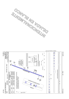
VAC chart of SPCL
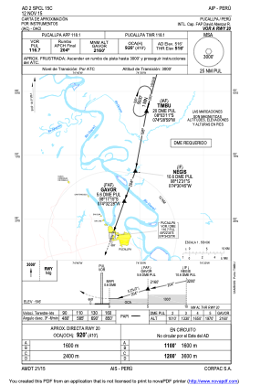
 IAC chart of SPCL
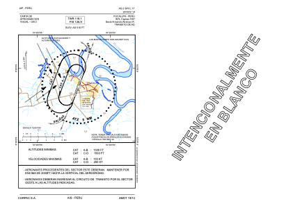
 ADC chart of SPCL
 Satellite view of SPCL
IAC chart of SPCLADC chart of SPCL
Satellite view of SPCL
Sorry, we have no imagery here.
Sorry, we have no imagery here.
Sorry, we have no imagery here.
Sorry, we have no imagery here.
Sorry, we have no imagery here.
Sorry, we have no imagery here.


SPCL - Aeropuerto Intl. Capitan Fap David Armando Abensur Rengifo
Located in Pucallpa, Peru
ICAO - SPCL, IATA - PCL
Data provided by AirmateGeneral information
Coordinates: S8°22'41" W74°34'27"
Elevation is 516 feet MSL.
View others Airports in Ucayali Region
Operational data
Special qualification required
Current time UTC:
Current local time:
Weather
METAR: SPCL 171300Z 17003KT 9999 SCT015 SCT070 25/23 Q1011 RMK BIRD HAZARD RWY 02/20 PP000
TAF: TAF SPCL 171100Z 1712/1812 VRB04KT 9999 SCT020 BKN080 TX31/1719Z TN23/1811Z TEMPO 1719/1722 4000 SHRA BKN012 FEW025TCU BKN080 TEMPO 1808/1812 3000 RA BKN008 FEW025TCU BKN080
Communications frequencies: [VIEW]
Runways:
| RWY identifier | QFU | Length (ft) | Width (ft) | Surface | LDA (ft) |
| 02 | 20° | 9186 | 148 | ASP | |
| 20 | 200° | 9186 | 148 | ASP |
Airport contact information
Address: Pucallpa Peru
Satellite view of SPCL
Sorry, we have no imagery here.
Sorry, we have no imagery here.
Sorry, we have no imagery here.
Sorry, we have no imagery here.
Sorry, we have no imagery here.
Sorry, we have no imagery here.