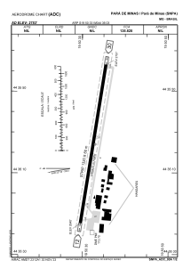
ADC chart of SNPA
 Satellite view of SNPA
Satellite view of SNPA
Sorry, we have no imagery here.
Sorry, we have no imagery here.
Sorry, we have no imagery here.
Sorry, we have no imagery here.
Sorry, we have no imagery here.
Sorry, we have no imagery here.


SNPA - Para De Minas
Located in Para De Minas, Brazil
ICAO - SNPA, IATA -
Data provided by AirmateGeneral information
Coordinates: S19°50'33" W44°36'3"
Elevation is 2752 feet MSL.
Magnetic variation is -22.808041182° East View others Airports in Minas Gerais
Operational data
Special qualification required
Current time UTC:
Current local time:
Weather at : SBBH - Pampulha - Carlos Drummond De Andrade ( 68 km )
METAR: SBBH 071500Z 09006KT 9999 BKN033 24/16 Q1021
Communications frequencies: [VIEW]
Runways:
| RWY identifier | QFU | Length (ft) | Width (ft) | Surface | LDA (ft) |
| 12 | 0° | 4331 | 197 | ASPH | |
| 30 | 0° | 4331 | 197 | ASPH |
Airport contact information
Address: Para De Minas Brazil
Satellite view of SNPA
Sorry, we have no imagery here.
Sorry, we have no imagery here.
Sorry, we have no imagery here.
Sorry, we have no imagery here.
Sorry, we have no imagery here.
Sorry, we have no imagery here.