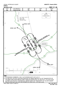
VAC chart of SNLI
 Satellite view of SNLI
Satellite view of SNLI
Sorry, we have no imagery here.
Sorry, we have no imagery here.
Sorry, we have no imagery here.
Sorry, we have no imagery here.
Sorry, we have no imagery here.
Sorry, we have no imagery here.


SNLI - Doutor Jose Mourao
Located in Abaete, Brazil
ICAO - SNLI, IATA -
Data provided by AirmateGeneral information
Coordinates: S19°9'21" W45°29'42"
Elevation is 2178 feet MSL.
Magnetic variation is -22.572814127° East View others Airports in Minas Gerais
Operational data
Special qualification required
Current time UTC:
Current local time:
Weather at : - ( 0 km )
METAR: KSUE 070057Z AUTO 19016G20KT 10SM CLR 03/M04 A2985 RMK AO2 SLP115 T00281039
Communications frequencies: [VIEW]
Runways:
| RWY identifier | QFU | Length (ft) | Width (ft) | Surface | LDA (ft) |
| 17 | 0° | 4331 | 262 | ASPH | |
| 35 | 0° | 4331 | 262 | ASPH |
Airport contact information
Address: Abaete Brazil
Satellite view of SNLI
Sorry, we have no imagery here.
Sorry, we have no imagery here.
Sorry, we have no imagery here.
Sorry, we have no imagery here.
Sorry, we have no imagery here.
Sorry, we have no imagery here.