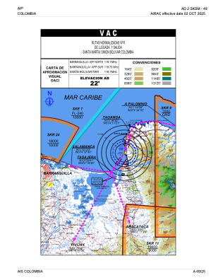
VAC chart of SKSM
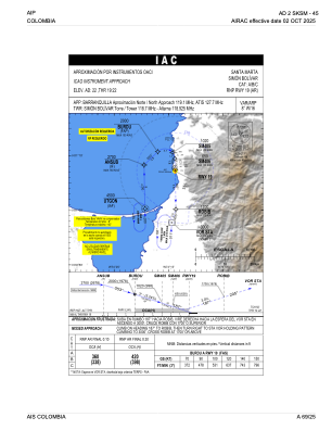
 IAC chart of SKSM
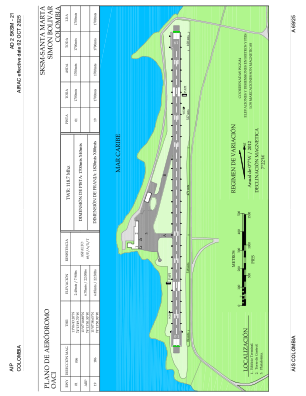
 ADC chart of SKSM
 Satellite view of SKSM
IAC chart of SKSMADC chart of SKSM
Satellite view of SKSM
Sorry, we have no imagery here.
Sorry, we have no imagery here.
Sorry, we have no imagery here.
Sorry, we have no imagery here.
Sorry, we have no imagery here.
Sorry, we have no imagery here.


SKSM - Santa Marta-Simon Bolivar
Located in Santa Marta, Colombia
ICAO - SKSM, IATA - SMR
Data provided by AirmateGeneral information
Coordinates: N11°7'11" W74°13'50"
Elevation is 22 feet MSL.
Magnetic variation is -9° East View others Airports in Magdalena
Operational data
Special qualification required
Current time UTC:
Current local time:
Weather
METAR: SKSM 112300Z VRB06KT 9999 DZ BKN030 28/25 Q1010
TAF: TAF SKSM 112255Z 1200/1224 36010KT 9999 FEW020 TEMPO 1200/1203 9999 TS FEW020CB TEMPO 1218/1221 8000 TSRA FEW020CB BKN025 TX32/1218Z TN24/1210Z
Communications frequencies: [VIEW]
Runways:
| RWY identifier | QFU | Length (ft) | Width (ft) | Surface | LDA (ft) |
| 01 | 359° | 5577 | 131 | ASPH | 5577 |
| 19 | 179° | 5577 | 131 | ASPH | 5577 |
Airport contact information
Address: Santa Marta Colombia
Satellite view of SKSM
Sorry, we have no imagery here.
Sorry, we have no imagery here.
Sorry, we have no imagery here.
Sorry, we have no imagery here.
Sorry, we have no imagery here.
Sorry, we have no imagery here.