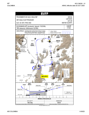
IAC chart of SKSG
 Satellite view of SKSG
Satellite view of SKSG
Sorry, we have no imagery here.
Sorry, we have no imagery here.
Sorry, we have no imagery here.
Sorry, we have no imagery here.
Sorry, we have no imagery here.
Sorry, we have no imagery here.


SKSG - Los Pozos
Located in , Colombia
ICAO - SKSG, IATA -
Data provided by AirmateGeneral information
Coordinates: N6°35'26" W73°7'45"
Elevation is 5579 feet MSL.
Magnetic variation is -9° East View others Airports in Santander
Operational data
Special qualification required
Current time UTC:
Current local time:
Weather at : SKBG - Palonegro ( 60 km )
METAR: SKBG 220200Z 33003KT 290V010 8000 VCTS FEW020CB SCT030 22/21 Q1015 RMK CB VCTS/S/SW
TAF: TAF SKBG 212255Z 2200/2224 31008KT 9999 SCT040 PROB30 TEMPO 2209/2211 5000 BR TEMPO 2221/2223 TSRA SCT020CB TX28/2219Z TN20/2210Z
Communications frequencies: [VIEW]
Runways:
| RWY identifier | QFU | Length (ft) | Width (ft) | Surface | LDA (ft) |
| 18 | 173° | 4314 | 94 | GRAV | |
| 23 | 0° | 0 | 0 | UNK | |
| 36 | 353° | 4314 | 94 | GRAV |
Airport contact information
Address: Colombia
Satellite view of SKSG
Sorry, we have no imagery here.
Sorry, we have no imagery here.
Sorry, we have no imagery here.
Sorry, we have no imagery here.
Sorry, we have no imagery here.
Sorry, we have no imagery here.