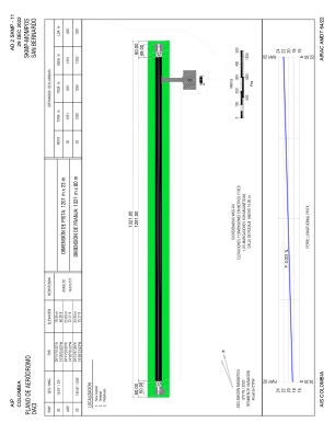
ADC chart of SKMP
 Satellite view of SKMP
Satellite view of SKMP
Sorry, we have no imagery here.
Sorry, we have no imagery here.
Sorry, we have no imagery here.
Sorry, we have no imagery here.
Sorry, we have no imagery here.
Sorry, we have no imagery here.


SKMP - San Bernardo
Located in , Colombia
ICAO - SKMP, IATA - MMP
Data provided by AirmateGeneral information
Coordinates: N9°15'30" W74°26'18"
Elevation is 72 feet MSL.
Magnetic variation is -8° East View others Airports in Bolívar
Operational data
Special qualification required
Current time UTC:
Current local time:
Weather at : - ( 0 km )
METAR: UUOO 020207Z 00000MPS 0250 0150NW R12/0550D FG NSC 05/05 Q1012 R12/290155 NOSIG RMK QFE745
Communications frequencies: [VIEW]
Runways:
| RWY identifier | QFU | Length (ft) | Width (ft) | Surface | LDA (ft) |
| 02 | 15° | 3860 | 62 | ASPH | 3940 |
| 20 | 195° | 3860 | 62 | ASPH | 3940 |
Airport contact information
Address: Colombia
Satellite view of SKMP
Sorry, we have no imagery here.
Sorry, we have no imagery here.
Sorry, we have no imagery here.
Sorry, we have no imagery here.
Sorry, we have no imagery here.
Sorry, we have no imagery here.