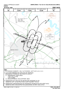
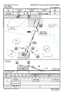
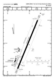


SBUL - Tenente Coronel Aviador Cesar Bombonato
Located in Uberlandia, Brazil
ICAO - SBUL, IATA - UDI
Data provided by AirmateGeneral information
Coordinates: S18°53'1" W48°13'31"
Elevation is 3094 feet MSL.
Magnetic variation is -21.833333333° East View others Airports in Minas Gerais
Operational data
Special qualification required
Current time UTC:
Current local time:
Weather
METAR: SBUL 212000Z 31005KT 9999 FEW030 26/18 Q1013
TAF: TAF SBUL 211400Z 2118/2206 14005KT 9999 SCT035 FEW040TCU TX30/2118Z TN22/2205Z TEMPO 2118/2201 21005KT 7000 TSRA FEW004 SCT023 FEW050CB PROB30 2201/2206 10005KT 6000 RA BKN007 RMK PGF
Communications frequencies: [VIEW]
Runways:
| RWY identifier | QFU | Length (ft) | Width (ft) | Surface | LDA (ft) |
| 22 | 0° | 7283 | 919 | ASPH | |
| 04 | 0° | 7283 | 919 | ASPH |
Airport contact information
Address: Uberlandia Brazil
