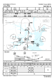
IAC chart of SBTU
 Satellite view of SBTU
Satellite view of SBTU
Sorry, we have no imagery here.
Sorry, we have no imagery here.
Sorry, we have no imagery here.
Sorry, we have no imagery here.
Sorry, we have no imagery here.
Sorry, we have no imagery here.


SBTU - Tucuruí
Located in Tucuruí, Brazil
ICAO - SBTU, IATA - TUR
Data provided by AirmateGeneral information
Coordinates: S3°46'37" W49°43'11"
Elevation is 830 feet MSL.
Magnetic variation is -20.466666667° East View others Airports in Pará
Operational data
Special qualification required
Current time UTC:
Current local time:
Weather
METAR: SBTU 271900Z AUTO 29006KT 220V330 9999 // SCT041/// 31/22 Q1013
Communications frequencies: [VIEW]
Runways:
| RWY identifier | QFU | Length (ft) | Width (ft) | Surface | LDA (ft) |
| 20 | 0° | 6955 | 492 | ASPH | |
| 02 | 0° | 6955 | 492 | ASPH |
Airport contact information
Address: Tucuruí Brazil
Satellite view of SBTU
Sorry, we have no imagery here.
Sorry, we have no imagery here.
Sorry, we have no imagery here.
Sorry, we have no imagery here.
Sorry, we have no imagery here.
Sorry, we have no imagery here.