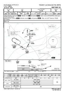
IAC chart of SBTD
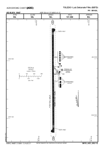
 ADC chart of SBTD
 Satellite view of SBTD
ADC chart of SBTD
Satellite view of SBTD
Sorry, we have no imagery here.
Sorry, we have no imagery here.
Sorry, we have no imagery here.
Sorry, we have no imagery here.
Sorry, we have no imagery here.
Sorry, we have no imagery here.


SBTD - Luis Dal Canalle Filho
Located in Toledo, Brazil
ICAO - SBTD, IATA - TOW
Data provided by AirmateGeneral information
Coordinates: S24°41'7" W53°41'47"
Elevation is 1841 feet MSL.
Magnetic variation is -17.916666667° East View others Airports in Paraná
Operational data
Special qualification required
Current time UTC:
Current local time:
Communications frequencies: [VIEW]
Runways:
| RWY identifier | QFU | Length (ft) | Width (ft) | Surface | LDA (ft) |
| 20 | 0° | 5479 | 98 | ASPH | |
| 02 | 0° | 5479 | 98 | ASPH |
Airport contact information
Address: Toledo Brazil
Other aviation service providers
Aviation club (not for profit)

Aeroeste-Aeroclube Oeste Do Paraná
Aeroeste-Aeroclube Oeste Do Paraná
aeroclubedetoledo@ibest.com.br+55453278-6160
Satellite view of SBTD
Sorry, we have no imagery here.
Sorry, we have no imagery here.
Sorry, we have no imagery here.
Sorry, we have no imagery here.
Sorry, we have no imagery here.
Sorry, we have no imagery here.