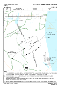
VAC chart of SBPW
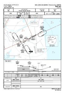
 IAC chart of SBPW
 Satellite view of SBPW
IAC chart of SBPW
Satellite view of SBPW
Sorry, we have no imagery here.
Sorry, we have no imagery here.
Sorry, we have no imagery here.
Sorry, we have no imagery here.
Sorry, we have no imagery here.
Sorry, we have no imagery here.


SBPW - Porto Do Açu
Located in São João Da Barra, Brazil
ICAO - SBPW, IATA -
Data provided by AirmateGeneral information
Coordinates: S21°48'15" W41°6'32"
Elevation is 18 feet MSL.
Magnetic variation is -23.683333333° East View others Airports in Rio de Janeiro
Operational data
Special qualification required
Current time UTC:
Current local time:
Weather at : SBCP - Bartolomeu Lisandro ( 24 km )
TAF: TAF SBCP 200300Z 2006/2018 21010KT CAVOK TN16/2009Z TX24/2017Z BECMG 2012/2014 23010KT SCT020 RMK PGY
Communications frequencies: [VIEW]
Runways:
| RWY identifier | QFU | Length (ft) | Width (ft) | Surface | LDA (ft) |
| 08 | 0° | 1243 | 103 | UNK | |
| 26 | 0° | 1243 | 103 | UNK |
Airport contact information
Address: São João Da Barra Brazil
Satellite view of SBPW
Sorry, we have no imagery here.
Sorry, we have no imagery here.
Sorry, we have no imagery here.
Sorry, we have no imagery here.
Sorry, we have no imagery here.
Sorry, we have no imagery here.