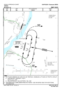
VAC chart of SBOI
 IAC chart of SBOI
 Satellite view of SBOI
IAC chart of SBOI
Satellite view of SBOI
Sorry, we have no imagery here.
Sorry, we have no imagery here.
Sorry, we have no imagery here.
Sorry, we have no imagery here.
Sorry, we have no imagery here.
Sorry, we have no imagery here.


SBOI - Oiapoque
Located in Oiapoque, Brazil
ICAO - SBOI, IATA - OYK
Data provided by AirmateGeneral information
Coordinates: N3°51'15" W51°47'50"
Elevation is 53 feet MSL.
Magnetic variation is -18.783333333° East View others Airports in Amapá
Operational data
Special qualification required
Current time UTC:
Current local time:
Weather
METAR: SBOI 111100Z AUTO VRB02KT 9999 FEW023 25/24 Q1012
TAF: TAF SBOI 110900Z 1112/1124 36003KT 9999 SCT015 TX30/1116Z TN25/1124Z BECMG 1113/1115 04005KT SCT025 RMK PHD
Communications frequencies: [VIEW]
Runways:
| RWY identifier | QFU | Length (ft) | Width (ft) | Surface | LDA (ft) |
| 21 | 0° | 5315 | 459 | ASPH | |
| 03 | 0° | 5315 | 459 | ASPH |
Airport contact information
Address: Oiapoque Brazil
Satellite view of SBOI
Sorry, we have no imagery here.
Sorry, we have no imagery here.
Sorry, we have no imagery here.
Sorry, we have no imagery here.
Sorry, we have no imagery here.
Sorry, we have no imagery here.