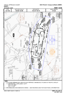
VAC chart of SBMT
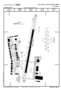
 ADC chart of SBMT
 Satellite view of SBMT
ADC chart of SBMT
Satellite view of SBMT
Sorry, we have no imagery here.
Sorry, we have no imagery here.
Sorry, we have no imagery here.
Sorry, we have no imagery here.
Sorry, we have no imagery here.
Sorry, we have no imagery here.


SBMT - Campo De Marte
Located in São Paulo, Brazil
ICAO - SBMT, IATA -
Data provided by AirmateGeneral information
Coordinates: S23°30'33" W46°38'15"
Elevation is 2372 feet MSL.
Magnetic variation is -21.766666667° East View others Airports in São Paulo
Operational data
Special qualification required
Current time UTC:
Current local time:
Weather
METAR: SBMT 112000Z 17010KT 9999 FEW020 22/17 Q1016
Communications frequencies: [VIEW]
Runways:
| RWY identifier | QFU | Length (ft) | Width (ft) | Surface | LDA (ft) |
| 12 | 0° | 5643 | 262 | ASPH | |
| 30 | 0° | 5643 | 262 | ASPH |
Airport contact information
Address: São Paulo Brazil
Satellite view of SBMT
Sorry, we have no imagery here.
Sorry, we have no imagery here.
Sorry, we have no imagery here.
Sorry, we have no imagery here.
Sorry, we have no imagery here.
Sorry, we have no imagery here.