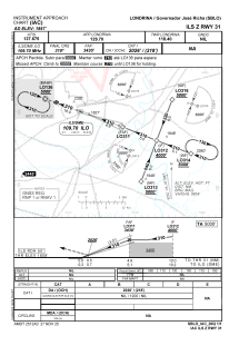
IAC chart of SBLO
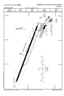
 ADC chart of SBLO
 Satellite view of SBLO
ADC chart of SBLO
Satellite view of SBLO
Sorry, we have no imagery here.
Sorry, we have no imagery here.
Sorry, we have no imagery here.
Sorry, we have no imagery here.
Sorry, we have no imagery here.
Sorry, we have no imagery here.


SBLO - Governador José Richa
Located in Londrina, Brazil
ICAO - SBLO, IATA - LDB
Data provided by AirmateGeneral information
Coordinates: S23°19'49" W51°8'12"
Elevation is 1867 feet MSL.
Magnetic variation is -19.75° East View others Airports in Paraná
Operational data
Special qualification required
Current time UTC:
Current local time:
Weather
METAR: SBLO 111700Z 06005KT 9999 SCT040 29/19 Q1014
TAF: TAF SBLO 111545Z 1118/1206 16007KT 9999 FEW040 TX30/1118Z TN22/1205Z BECMG 1121/1123 15010KT RMK PGM
Communications frequencies: [VIEW]
Runways:
| RWY identifier | QFU | Length (ft) | Width (ft) | Surface | LDA (ft) |
| 13 | 0° | 7283 | 919 | ASPH | |
| 31 | 0° | 7283 | 919 | ASPH |
Airport contact information
Address: Londrina Brazil
Other aviation service providers
Aviation club (not for profit)

Satellite view of SBLO
Sorry, we have no imagery here.
Sorry, we have no imagery here.
Sorry, we have no imagery here.
Sorry, we have no imagery here.
Sorry, we have no imagery here.
Sorry, we have no imagery here.