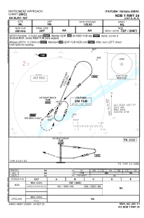
IAC chart of SBIH
 Satellite view of SBIH
Satellite view of SBIH
Sorry, we have no imagery here.
Sorry, we have no imagery here.
Sorry, we have no imagery here.
Sorry, we have no imagery here.
Sorry, we have no imagery here.
Sorry, we have no imagery here.


SBIH - Itaituba
Located in Itaituba, Brazil
ICAO - SBIH, IATA - ITB
Data provided by AirmateGeneral information
Coordinates: S4°14'32" W56°0'3"
Elevation is 102 feet MSL.
Magnetic variation is -18.416666667° East View others Airports in Pará
Operational data
Special qualification required
Current time UTC:
Current local time:
Weather
TAF: TAF SBIH 202115Z 2100/2112 07005KT 8000 BKN020 TN24/2108Z TX26/2112Z BECMG 2100/2102 02005KT TEMPO 2109/2112 3500 BCFG SCT007 BKN013 RMK PGW
Communications frequencies: [VIEW]
Runways:
| RWY identifier | QFU | Length (ft) | Width (ft) | Surface | LDA (ft) |
| 06 | 0° | 5971 | 459 | ASPH | |
| 24 | 0° | 5971 | 459 | ASPH |
Airport contact information
Address: Itaituba Brazil
Satellite view of SBIH
Sorry, we have no imagery here.
Sorry, we have no imagery here.
Sorry, we have no imagery here.
Sorry, we have no imagery here.
Sorry, we have no imagery here.
Sorry, we have no imagery here.