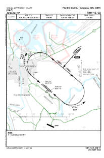
VAC chart of SBFI
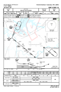
 IAC chart of SBFI
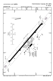
 ADC chart of SBFI
 Satellite view of SBFI
IAC chart of SBFIADC chart of SBFI
Satellite view of SBFI
Sorry, we have no imagery here.
Sorry, we have no imagery here.
Sorry, we have no imagery here.
Sorry, we have no imagery here.
Sorry, we have no imagery here.
Sorry, we have no imagery here.


SBFI - Cataratas
Located in Foz Do Iguaçu, Brazil
ICAO - SBFI, IATA - IGU
Data provided by AirmateGeneral information
Coordinates: S25°36'1" W54°29'6"
Elevation is 787 feet MSL.
Magnetic variation is -16.944385853° East View others Airports in Paraná
Operational data
Special qualification required
Current time UTC:
Current local time:
Weather
TAF: TAF SBFI 112100Z 1200/1224 09005KT 9999 FEW020 TN20/1209Z TX22/1212Z BECMG 1210/1212 7000 BKN020 FEW025TCU TEMPO 1216/1221 3500 -TSRA BKN010 FEW025CB RMK PDZ
Communications frequencies: [VIEW]
Runways:
| RWY identifier | QFU | Length (ft) | Width (ft) | Surface | LDA (ft) |
| 15 | 131° | 7154 | 146 | ASPH | |
| 33 | 311° | 7154 | 146 | ASPH |
Airport contact information
Address: Foz Do Iguaçu Brazil
Satellite view of SBFI
Sorry, we have no imagery here.
Sorry, we have no imagery here.
Sorry, we have no imagery here.
Sorry, we have no imagery here.
Sorry, we have no imagery here.
Sorry, we have no imagery here.