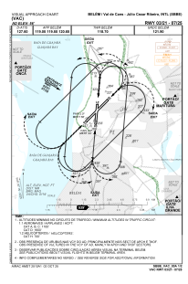
VAC chart of SBBE
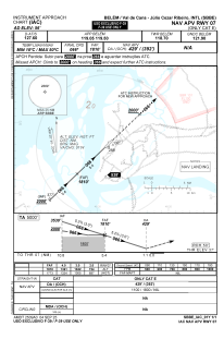
 IAC chart of SBBE
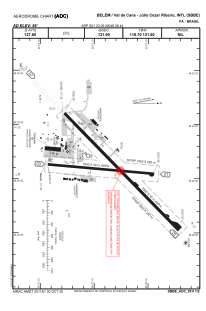
 ADC chart of SBBE
 Satellite view of SBBE
IAC chart of SBBEADC chart of SBBE
Satellite view of SBBE
Sorry, we have no imagery here.
Sorry, we have no imagery here.
Sorry, we have no imagery here.
Sorry, we have no imagery here.
Sorry, we have no imagery here.
Sorry, we have no imagery here.


SBBE - Val De Cans - Júlio Cezar Ribeiro
Located in Belém, Brazil
ICAO - SBBE, IATA - BEL
Data provided by AirmateGeneral information
Coordinates: S1°23'5" W48°28'44"
Elevation is 55 feet MSL.
Magnetic variation is -20.193635138° East View others Airports in Pará
Operational data
Special qualification required
Current time UTC:
Current local time:
Weather
METAR: SBBE 251600Z 15004KT 9999 BKN035 31/25 Q1012
TAF: TAF SBBE 251612Z 2518/2618 08007KT 8000 SCT023 TX33/2518Z TN24/2609Z TEMPO 2518/2523 36010KT 7000 BKN030 FEW035TCU BECMG 2614/2617 35008KT BKN030 FEW035TCU TEMPO 2617/2618 06010KT 6000 TS BKN030 FEW035CB RMK PHC
Communications frequencies: [VIEW]
Runways:
| RWY identifier | QFU | Length (ft) | Width (ft) | Surface | LDA (ft) |
| 02 | 5° | 6398 | 919 | ASPH | |
| 20 | 185° | 6398 | 919 | ASPH | |
| 06 | 45° | 9580 | 919 | ASPH | |
| 24 | 225° | 9580 | 919 | ASPH |
Airport contact information
Address: Belém Brazil
Satellite view of SBBE
Sorry, we have no imagery here.
Sorry, we have no imagery here.
Sorry, we have no imagery here.
Sorry, we have no imagery here.
Sorry, we have no imagery here.
Sorry, we have no imagery here.