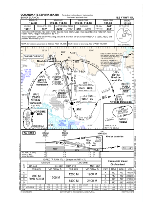
IAC chart of SAZB
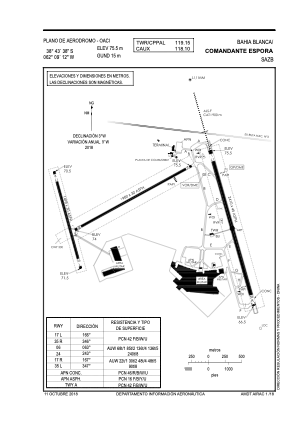
 ADC chart of SAZB
 Satellite view of SAZB
ADC chart of SAZB
Satellite view of SAZB
Sorry, we have no imagery here.
Sorry, we have no imagery here.
Sorry, we have no imagery here.
Sorry, we have no imagery here.
Sorry, we have no imagery here.
Sorry, we have no imagery here.


SAZB - Bahía Blanca / Cte. Espora
Located in Bahía Blanca, Argentina
ICAO - SAZB, IATA - BHI
Data provided by AirmateGeneral information
Coordinates: S38°43'39" W62°9'12"
Elevation is 246 feet MSL.
View others Airports in Buenos Aires Province
Operational data
Special qualification required
Current time UTC:
Current local time:
Communications frequencies: [VIEW]
Runways:
| RWY identifier | QFU | Length (ft) | Width (ft) | Surface | LDA (ft) |
| 06 | 0° | 6496 | 98 | UNK | |
| 24 | 241° | 6496 | 98 | ASP | |
| 17L | 0° | 7907 | 148 | UNK | |
| 35R | 0° | 7907 | 148 | UNK | |
| 17R | 0° | 4915 | 98 | UNK | |
| 35L | 0° | 4915 | 98 | UNK |
Airport contact information
Address: Bahía Blanca Argentina
Satellite view of SAZB
Sorry, we have no imagery here.
Sorry, we have no imagery here.
Sorry, we have no imagery here.
Sorry, we have no imagery here.
Sorry, we have no imagery here.
Sorry, we have no imagery here.