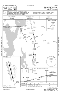
IAC chart of S43
 Satellite view of S43
Satellite view of S43
Sorry, we have no imagery here.
Sorry, we have no imagery here.
Sorry, we have no imagery here.
Sorry, we have no imagery here.
Sorry, we have no imagery here.


S43 - Harvey Fld
Located in Snohomish, United States
ICAO - S43, IATA -
Data provided by AirmateGeneral information
Coordinates: N47°54'18" W122°6'10"
Elevation is 23 feet MSL.
Magnetic variation is 17° East View others Airports in Washington
Operational data
Special qualification required
Current time UTC:
Current local time:
Weather at : KPAE - Seattle Paine Fld Intl ( 13 km )
METAR: KPAE 050653Z AUTO 10003KT 10SM CLR 10/04 A3031 RMK AO2 SLP265 T01000044
TAF: KPAE 050524Z 0506/0606 VRB03KT P6SM SKC FM050700 13005KT P6SM SKC FM051300 15004KT P6SM SCT250 FM051800 18007KT P6SM BKN250 FM060200 17005KT P6SM BKN100
Communications frequencies: [VIEW]
Runways:
| RWY identifier | QFU | Length (ft) | Width (ft) | Surface | LDA (ft) |
| 15L | 165° | 2672 | 36 | ASPH | |
| 33R | 345° | 2672 | 36 | ASPH | |
| 15R | 165° | 2430 | 100 | GRASS | |
| 33L | 345° | 2430 | 100 | GRASS | |
| H1 | 0° | 0 | 0 | UNK |
Airport contact information
Address: Snohomish United States
Other aviation service providers
Flight schools

Satellite view of S43
Sorry, we have no imagery here.
Sorry, we have no imagery here.
Sorry, we have no imagery here.
Sorry, we have no imagery here.
Sorry, we have no imagery here.