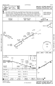
IAC chart of S24
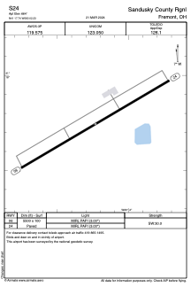
 ADC chart of S24
 Satellite view of S24
ADC chart of S24
Satellite view of S24
Sorry, we have no imagery here.
Sorry, we have no imagery here.
Sorry, we have no imagery here.
Sorry, we have no imagery here.
Sorry, we have no imagery here.
Sorry, we have no imagery here.


S24 - Sandusky County Rgnl
Located in Fremont, United States
ICAO - S24, IATA -
Data provided by AirmateGeneral information
Coordinates: N41°17'45" W83°2'14"
Elevation is 665 feet MSL.
Magnetic variation is -07° East View others Airports in Ohio
Operational data
Special qualification required
Current time UTC:
Current local time:
Weather at : KPCW - Erie-Ottawa Intl ( 28 km )
METAR: KPCW 080345Z AUTO 34016G24KT 10SM BKN035 BKN043 00/M06 A2993 RMK AO2
Communications frequencies: [VIEW]
Runways:
| RWY identifier | QFU | Length (ft) | Width (ft) | Surface | LDA (ft) |
| 06 | 60° | 5500 | 100 | ASPH | |
| 24 | 240° | 5500 | 100 | ASPH |
Airport contact information
Address: Fremont United States
Satellite view of S24
Sorry, we have no imagery here.
Sorry, we have no imagery here.
Sorry, we have no imagery here.
Sorry, we have no imagery here.
Sorry, we have no imagery here.
Sorry, we have no imagery here.