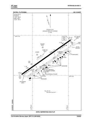
ADC chart of ROTM
 Satellite view of ROTM
Satellite view of ROTM
Sorry, we have no imagery here.
Sorry, we have no imagery here.
Sorry, we have no imagery here.
Sorry, we have no imagery here.
Sorry, we have no imagery here.
Sorry, we have no imagery here.


ROTM - Futenma
Located in Naha, Japan
ICAO - ROTM, IATA -
Data provided by AirmateGeneral information
Coordinates: N26°16'15" E127°44'53"
Elevation is 248 feet MSL.
View others Airports in Okinawa Prefecture
Operational data
Special qualification required
Current time UTC:
Current local time:
Weather
METAR: ROTM 111956Z AUTO 16005KT 10SM CLR A2988 RMK AO2 SLPNO $
TAF: TAF ROTM 1113/1213 VRB06KT 9999 FEW030 511602 QNH2989INS FM112100 15009KT 9999 SCT030 BKN140 621407 500000 QNH2991INS BECMG 1201/1203 17013G23KT 9999 SCT030 OVC100 621407 QNH2982INS BECMG 1209/1211 17012G22KT 9999 BKN025 OVC060 621409 QNH2982INS T19/1118Z T24/1205Z LAST NO AMDS AFT 1113 NEXT 1205
Communications frequencies: [VIEW]
Runways:
| RWY identifier | QFU | Length (ft) | Width (ft) | Surface | LDA (ft) |
| 06 | 55° | 9004 | 150 | ASP | |
| 24 | 235° | 9004 | 150 | ASP |
Airport contact information
Address: Naha Japan
Satellite view of ROTM
Sorry, we have no imagery here.
Sorry, we have no imagery here.
Sorry, we have no imagery here.
Sorry, we have no imagery here.
Sorry, we have no imagery here.
Sorry, we have no imagery here.